


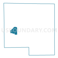
PECATONICA 4 Voting District, Winnebago County, Illinois
About
Outline

Summary
| Unique Area Identifier | 575761 |
| Name | PECATONICA 4 Voting District |
| County | Winnebago County |
| State | Illinois |
| Area (square miles) | 7.66 |
| Land Area (square miles) | 7.66 |
| Water Area (square miles) | 0.00 |
| % of Land Area | 100.00 |
| % of Water Area | 0.00 |
| Latitude of the Internal Point | 42.31465690 |
| Longtitude of the Internal Point | -89.30539620 |
Maps

Graphs
Select a template below for downloading or customizing gragh for PECATONICA 4 Voting District, Winnebago County, Illinois


Neighbors
Neighoring Voting District (by Name) Neighboring Voting District on the Map
- BURRITT 1 Voting District, Winnebago County, IL
- PECATONICA 2 Voting District, Winnebago County, IL
- PECATONICA 3 Voting District, Winnebago County, IL
- SEWARD 1 Voting District, Winnebago County, IL
- WINNEBAGO 1 Voting District, Winnebago County, IL
Top 10 Neighboring County Subdivision (by Population) Neighboring County Subdivision on the Map
- Winnebago township, Winnebago County, IL (5,291)
- Pecatonica township, Winnebago County, IL (4,355)
- Burritt township, Winnebago County, IL (947)
- Seward township, Winnebago County, IL (917)
Top 10 Neighboring Unified School District (by Population) Neighboring Unified School District on the Map
- Winnebago Community Unit School District 323, IL (8,157)
- Pecatonica Community Unit School District 321, IL (5,261)